Stonehenge
From Wikipedia, the free encyclopedia
For other uses, see Stonehenge (disambiguation).
| Stonehenge, Avebury and Associated Sites | |
|---|---|
| Name as inscribed on the World Heritage List | |
 | |
| Country | United Kingdom |
| Type | Cultural |
| Criteria | i, ii, iii |
| Reference | 373 |
| UNESCO region | Europe and North America |
| Inscription history | |
| Inscription | 1986 (10th Session) |
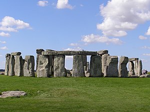
Stonehenge is a prehistoric monument in Wiltshire, England, about 2 miles (3.2 km) west of Amesbury and 8 miles (13 km) north of Salisbury. One of the most famous sites in the world, Stonehenge is the remains of a ring of standing stones set within earthworks. It is in the middle of the most dense complex ofNeolithic and Bronze Age monuments in England, including several hundredburial mounds.[1]
Archaeologists believe it was built anywhere from 3000 BC to 2000 BC.Radiocarbon dating in 2008 suggested that the first stones were raised between 2400 and 2200 BC,[2] whilst another theory suggests that bluestones may have been raised at the site as early as 3000 BC.[3][4][5]
The surrounding circular earth bank and ditch, which constitute the earliest phase of the monument, have been dated to about 3100 BC. The site and its surroundings were added to the UNESCO's list of World Heritage Sites in 1986 in a co-listing with Avebury Henge. It is a national legally protected Scheduled Ancient Monument. Stonehenge is owned by the Crown and managed byEnglish Heritage, while the surrounding land is owned by the National Trust.[6][7]
Archaeological evidence found by the Stonehenge Riverside Project in 2008 indicates that Stonehenge could have been a burial ground from its earliest beginnings.[8] The dating of cremated remains found on the site indicate that deposits contain human bone from as early as 3000 BC, when the ditch and bank were first dug. Such deposits continued at Stonehenge for at least another 500 years.[9] The site is a place of religious significance and pilgrimage in Neo-Druidry.
Etymology
The Oxford English Dictionary cites Ælfric's 10th-century glossary, in which henge-cliff is given the meaning "precipice", or stone, thus the stanenges or Stanheng "not far from Salisbury" recorded by 11th-century writers are "supported stones". William Stukeley in 1740 notes, "Pendulous rocks are now called henges in Yorkshire...I doubt not, Stonehenge in Saxon signifies the hanging stones."[10]Christopher Chippindale's Stonehenge Complete gives the derivation of the name Stonehenge as coming from the Old English wordsstān meaning "stone", and either hencg meaning "hinge" (because the stone lintels hinge on the upright stones) or hen(c)en meaning "hang" or "gallows" or "instrument of torture". Like Stonehenge's trilithons, medieval gallows consisted of two uprights with a lintel joining them, rather than the inverted L-shape more familiar today.
The "henge" portion has given its name to a class of monuments known as henges.[10] Archaeologists define henges as earthworks consisting of a circular banked enclosure with an internal ditch.[11] As often happens in archaeological terminology, this is a holdover from antiquarian usage, and Stonehenge is not truly a henge site as its bank is inside its ditch. Despite being contemporary with trueNeolithic henges and stone circles, Stonehenge is in many ways atypical – for example, at over 7.3 metres (24 ft) tall, its extant trilithons supporting lintels held in place with mortise and tenon joints, make it unique.[12][13]
Early history
Mike Parker Pearson, leader of the Stonehenge Riverside Project based at Durrington Walls, noted that Stonehenge appears to have been associated with burial from the earliest period of its existence:
Stonehenge was a place of burial from its beginning to its zenith in the mid third millennium B.C. The cremation burial dating to Stonehenge's sarsen stones phase is likely just one of many from this later period of the monument's use and demonstrates that it was still very much a domain of the dead.[9]— Mike Parker Pearson
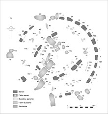
Stonehenge evolved in several construction phases spanning at least 1,500 years. There is evidence of large-scale construction on and around the monument that perhaps extends the landscape's time frame to 6,500 years. Dating and understanding the various phases of activity is complicated by disturbance of the natural chalk by periglacial effects and animal burrowing, poor quality early excavation records, and a lack of accurate, scientifically verified dates. The modern phasing most generally agreed to by archaeologists is detailed below. Features mentioned in the text are numbered and shown on the plan, right.
Before the monument (8000 BC forward)
Archaeologists have found four, or possibly five, large Mesolithic postholes (one may have been a natural tree throw), which date to around 8000 BC, beneath the nearby modern tourist car-park. These held pine posts around 0.75 metres (2 ft 6 in) in diameter which were erected and eventually rotted in situ. Three of the posts (and possibly four) were in an east-west alignment which may have had ritual significance; no parallels are known from Britain at the time but similar sites have been found in Scandinavia. Salisbury Plain was then still wooded but 4,000 years later, during the earlier Neolithic, people built a causewayed enclosure at Robin Hood's Ball and long barrow tombs in the surrounding landscape. In approximately 3500 BC, a Stonehenge Cursus was built 700 metres (2,300 ft) north of the site as the first farmers began to clear the trees and develop the area.
Stonehenge 1 (ca. 3100 BC)
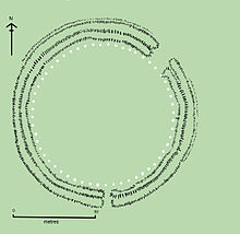
The first monument consisted of a circular bank and ditch enclosure made of Late Cretaceous(Santonian Age) Seaford Chalk, (7 and 8), measuring about 110 metres (360 ft) in diameter, with a large entrance to the north east and a smaller one to the south (14). It stood in opengrassland on a slightly sloping spot.[14] The builders placed the bones of deer and oxen in the bottom of the ditch, as well as some worked flint tools. The bones were considerably older than the antler picks used to dig the ditch, and the people who buried them had looked after them for some time prior to burial. The ditch was continuous but had been dug in sections, like the ditches of the earlier causewayed enclosures in the area. The chalk dug from the ditch was piled up to form the bank. This first stage is dated to around 3100 BC, after which the ditch began to silt up naturally. Within the outer edge of the enclosed area is a circle of 56 pits (13), each about a metre (3'3") in diameter, known as the Aubrey holes after John Aubrey, the 17th-century antiquarian who was thought to have first identified them. The pits may have contained standing timbers creating a timber circle, although there is no excavated evidence of them. A recent excavation has suggested that the Aubrey Holes may have originally been used to erect a bluestone circle.[15] If this were the case, it would advance the earliest known stone structure at the monument by some 500 years. A small outer bank beyond the ditch could also date to this period.
In 2013 a team of archaeologists, led by Professor Mike Parker Pearson, excavated more than 50000 cremated bones of 63 individuals buried at Stonehenge.[3][4] These remains had originally been buried individually in the Aubrey holes, exhumed during a previous excavation conducted by William Hawley in 1920, been considered unimportant by him, and subsequently re-interred together in one hole, Aubrey Hole 7, in 1935.[16] Physical and chemical analysis of the remains has shown that the cremated were almost equally men and women, and included some children.[3][4] As there was evidence of the underlying chalk beneath the graves being crushed by substantial weight, the team concluded that the first bluestones brought from Wales were probably used as grave markers.[3][4]Radiocarbon dating of the remains has put the date of the site 500 years earlier than previously estimated, to around 3,000 BCE.[3][4]
Analysis of animal teeth found at nearby Durrington Walls, thought to be the 'builders camp', suggests that as many as 4,000 people gathered at the site for the mid-winter and mid-summer festivals; the evidence showed that the animals had been slaughtered around 9 months or 15 months after their spring birth. Strontium isotope analysis of the animal teeth showed that some had travelled from as far afield as the Scottish Highlands for the celebrations.[4][5]
Stonehenge 2 (ca. 3000 BC)
Evidence of the second phase is no longer visible. The number of postholes dating to the early 3rd millennium BC suggest that some form of timber structure was built within the enclosure during this period. Further standing timbers were placed at the northeast entrance, and a parallel alignment of posts ran inwards from the southern entrance. The postholes are smaller than the Aubrey Holes, being only around 0.4 metres (16 in) in diameter, and are much less regularly spaced. The bank was purposely reduced in height and the ditch continued to silt up. At least twenty-five of the Aubrey Holes are known to have contained later, intrusive, cremation burials dating to the two centuries after the monument's inception. It seems that whatever the holes' initial function, it changed to become a funerary one during Phase 2. Thirty further cremations were placed in the enclosure's ditch and at other points within the monument, mostly in the eastern half. Stonehenge is therefore interpreted as functioning as an enclosed cremation cemetery at this time, the earliest known cremation cemetery in the British Isles. Fragments of unburnt human bone have also been found in the ditch-fill. Dating evidence is provided by the late Neolithic grooved ware pottery that has been found in connection with the features from this phase.
Stonehenge 3 I (ca. 2600 BC)
Archaeological excavation has indicated that around 2600 BC, the builders abandoned timber in favour of stone and dug two concentric arrays of holes (the Q and R Holes) in the centre of the site. These stone sockets are only partly known (hence on present evidence are sometimes described as forming ‘crescents’); however, they could be the remains of a double ring. Again, there is little firm dating evidence for this phase. The holes held up to 80 standing stones (shown blue on the plan), only 43 of which can be traced today. The bluestones (some of which are made of dolerite, an igneous rock), were thought for much of the 20th century to have been transported by humans from the Preseli Hills, 150 miles (240 km) away in modern-day Pembrokeshire in Wales. Another theory that has recently gained support is that they were brought much nearer to the site as glacial erratics by the Irish Sea Glacier.[17] Other standing stones may well have been small sarsens (limestones), used later as lintels. The stones, which weighed about four tons, consisted mostly of spotted Ordovician dolerite but included examples of rhyolite, tuff and volcanic and calcareous ash; in total around 20 different rock types are represented. Each monolith measures around 2 metres (6.6 ft) in height, between 1 m and 1.5 m (3.3–4.9 ft) wide and around 0.8 metres (2.6 ft) thick. What was to become known as the Altar Stone (1), is almost certainly derived from eitherCarmarthenshire or the Brecon Beacons and may have stood as a single large monolith.
The north-eastern entrance was widened at this time, with the result that it precisely matched the direction of the midsummer sunrise and midwinter sunset of the period. This phase of the monument was abandoned unfinished, however; the small standing stones were apparently removed and the Q and R holes purposefully backfilled. Even so, the monument appears to have eclipsed the site at Avebury in importance towards the end of this phase.
The Heelstone (5), a Tertiary sandstone, may also have been erected outside the north-eastern entrance during this period. It cannot be accurately dated and may have been installed at any time during phase 3. At first it was accompanied by a second stone, which is no longer visible. Two, or possibly three, large portal stones were set up just inside the north-eastern entrance, of which only one, the fallen Slaughter Stone (4), 4.9 metres (16 ft) long, now remains. Other features, loosely dated to phase 3, include the four Station Stones (6), two of which stood atop mounds (2 and 3). The mounds are known as "barrows" although they do not contain burials.Stonehenge Avenue, (10), a parallel pair of ditches and banks leading 2 miles (3.2 km) to the River Avon, was also added. Two ditches similar toHeelstone Ditch circling the Heelstone (which was by then reduced to a single monolith) were later dug around the Station Stones.
Stonehenge 3 II (2600 BC to 2400 BC)
During the next major phase of activity, 30 enormous Oligocene-Miocene sarsen stones(shown grey on the plan) were brought to the site. They may have come from a quarry, around 25 miles (40 km) north of Stonehenge on the Marlborough Downs, or they may have been collected from a "litter" of sarsens on the chalk downs, closer to hand. The stones weredressed and fashioned with mortise and tenon joints before 30 were erected as a 33 metres (108 ft) diameter circle of standing stones, with a ring of 30 lintel stones resting on top. The lintels were fitted to one another using another woodworking method, the tongue and groovejoint. Each standing stone was around 4.1 metres (13 ft) high, 2.1 metres (6 ft 11 in) wide and weighed around 25 tons. Each had clearly been worked with the final visual effect in mind; theorthostats widen slightly towards the top in order that their perspective remains constant when viewed from the ground, while the lintel stones curve slightly to continue the circular appearance of the earlier monument. The inward-facing surfaces of the stones are smoother and more finely worked than the outer surfaces. The average thickness of the stones is 1.1 metres (3 ft 7 in) and the average distance between them is 1 metre (3 ft 3 in). A total of 75 stones would have been needed to complete the circle (60 stones) and the trilithon horseshoe (15 stones). Unless some of the sarsens have since been removed from the site, the ring appears to have been left incomplete. The lintel stones are each around 3.2 metres (10 ft), 1 metre (3 ft 3 in) wide and 0.8 metres (2 ft 7 in) thick. The tops of the lintels are 4.9 metres (16 ft) above the ground.
Within this circle stood five trilithons of dressed sarsen stone arranged in a horseshoe shape 13.7 metres (45 ft) across with its open end facing north east. These huge stones, ten uprights and five lintels, weigh up to 50 tons each. They were linked using complex jointing. They are arranged symmetrically. The smallest pair of trilithons were around 6 metres (20 ft) tall, the next pair a little higher and the largest, single trilithon in the south west corner would have been 7.3 metres (24 ft) tall. Only one upright from the Great Trilithon still stands, of which 6.7 metres (22 ft) is visible and a further 2.4 metres (7 ft 10 in) is below ground.
The images of a 'dagger' and 14 'axeheads' have been carved on one of the sarsens, known as stone 53; further carvings of axeheads have been seen on the outer faces of stones 3, 4, and 5. The carvings are difficult to date, but are morphologically similar to late Bronze Age weapons; recent laser scanning work on the carvings supports this interpretation. The pair of trilithons in the north east are smallest, measuring around 6 metres (20 ft) in height; the largest, which is in the south west of the horseshoe, is almost 7.5 metres (25 ft) tall.
This ambitious phase has been radiocarbon dated to between 2600 and 2400 BC,[18] slightly earlier than the Stonehenge Archer, discovered in the outer ditch of the monument in 1978, and the two sets of burials, known as the Amesbury Archer and the Boscombe Bowmen, discovered 3 miles (4.8 km) to the west. At about the same time, a large timber circle and a second avenue were constructed 2 miles (3.2 km) away at Durrington Walls overlooking the River Avon. The timber circle was orientated towards the rising sun on the midwinter solstice, opposing the solar alignments at Stonehenge, whilst the avenue was aligned with the setting sun on the summer solstice and led from the river to the timber circle. Evidence of huge fires on the banks of the Avon between the two avenues also suggests that both circles were linked, and they were perhaps used as a procession route on the longest and shortest days of the year. Parker Pearson speculates that the wooden circle at Durrington Walls was the centre of a 'land of the living', whilst the stone circle represented a 'land of the dead', with the Avon serving as a journey between the two.[19]
Stonehenge 3 IV (2280 BC to 1930 BC)
This phase saw further rearrangement of the bluestones. They were arranged in a circle between the two rings of sarsens and in an oval at the centre of the inner ring. Some archaeologists argue that some of these bluestones were from a second group brought from Wales. All the stones formed well-spaced uprights without any of the linking lintels inferred in Stonehenge 3 III. The Altar Stone may have been moved within the oval at this time and re-erected vertically. Although this would seem the most impressive phase of work, Stonehenge 3 IV was rather shabbily built compared to its immediate predecessors, as the newly re-installed bluestones were not well-founded and began to fall over. However, only minor changes were made after this phase.
Stonehenge 3 V (1930 BC to 1600 BC)
Soon afterwards, the north eastern section of the Phase 3 IV bluestone circle was removed, creating a horseshoe-shaped setting (the Bluestone Horseshoe) which mirrored the shape of the central sarsen Trilithons. This phase is contemporary with the Seahenge site in Norfolk.


